Photo : Dr. H A Bharath
Bangalore of the yesteryears was a city of gardens; cool, pleasant and green. In addition to the 2000+ species of trees -- some natural and some specifically planted -- individual gardens in small households contributed to the large biodiversity here. The undulating terrain of the city allowed formation of lakes -- natural and manmade – that were interconnected. As the ‘Garden City’ transformed into the ‘Silicon Valley of India’, the city’s rapid, uncontrolled growth turned this biodiversity haven to a concrete jungle.
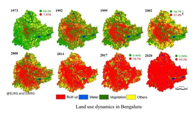
Here is a glimpse of the transformation -- the paved surfaces of Bangalore have increased by a whopping 1005%, yes 100 times, in the past 40 years! This came at the sacrifice of the green cover, reducing from 68% in 1973 to merely 25% in 2012. The area of ponds and lakes reduced to less than one third from 3.4% to just 1%. If the trend continues, Bangalore would be left with merely 3% of green cover in the next couple of years!
Yes, this startling discovery was made by scientists from Indian Institute of Technology, Kharagpur and the Indian Institute of Science, Bangalore. In a recently published study, they calculated the number of trees that form the green cover over Bangalore using satellite images over the period of 45 years, and found some very detailed and interesting results. Funded by the SERB division of Department of Science and Technology, the results of the study were published in the Journal of Environmental Management.
But in the 45 years, how did we get from being a ‘green’ city to a ‘grey’ one? “As population and its activities increase in a region, the boundary of the city expands to accommodate growth along the urban fringes, leading to urban sprawl with the fragmented urban morphology, thereby impacting local ecology at peri-urban areas and city outskirts”, says Dr. H.A. Bharath from IIT-Kharagpur, also a co-author of the study, detailing the reasons behind the urban sprawl that we witness now.
Researchers of the study used multi-resolution image data, captured through satellite sensors, to estimate the number of trees in the urban area. “Multi resolution means at different levels of spatial description. It is necessary to capture important aspects in different contexts”, explains Dr. Bharath on the use of multi-resolution images.
Once these images were processed, the researchers used various techniques to estimate the green cover and classify the land use for Bangalore. They extracted tree cover for the 198 wards that constitute Bangalore city. To validate the tree count thus obtained, they collected actual field data by counting the number of trees in select wards. They also analyzed image data over a period of time.
The ward-wise tree count showed a lot of variation in the number of trees in each ward. Some wards had more than 40,000 trees whereas some wards had less than 100 trees. The tree density also varied ranging from less than 1 tree per 500 persons to 1.25 trees per person. In addition, the study indicates that for every person in Bengaluru, there should have been 8 trees to offset the human respiratory carbon or to have adequate oxygen. However, in Bengaluru, there is just 1 tree for every 7 persons, quite a poor figure compared to 4 trees per person in Gandhinagar, Gujarat, and 2 trees per person in Nashik, Maharashtra.
A shortcoming of this study is that the technique used here captures only large trees; leaving out shorter, smaller trees that lie underneath these large trees. Nevertheless, it does indicate an alarming trend in the loss of green cover. So how do such studies help? “Spatial data available through satellite images can help in inventorying, mapping and monitoring of natural resources in a cost effective way. It can help in the understanding of urban growth pattern, urbanization rate, and the underlying problems of urban sprawl, etc. These, ultimately, aid in better administration through the provision of basic amenities”, signs off Dr. Bharath.