
 Precambrian to recent. Scientific Publishers.")
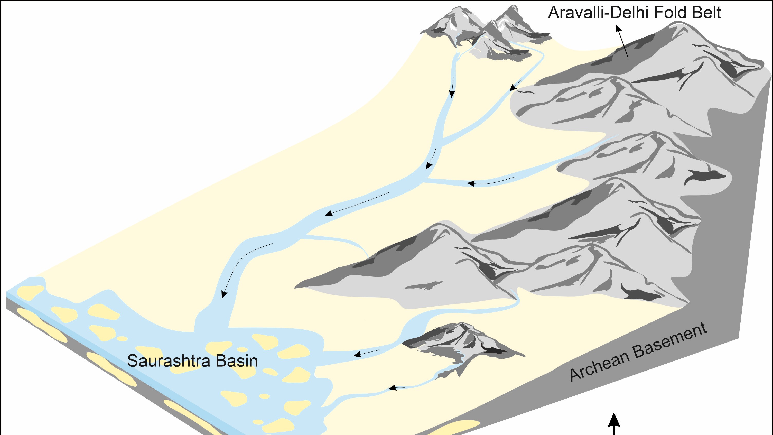
In Western India, spanning western Gujarat and the North of Mumbai coastline, lies the Saurashtra Basin which is an expanse of 2,40,000 SqKm area spanning sea and land. Much of the landscape here remains buried in volcanic rocks called Deccan Traps, created by volcanic eruptions at the Western Ghats during the Cretaceous period, 66 million years ago. However, the sediment beneath the volcanic ash and rocks hides the extraordinary journey of the Indian subcontinent over the millenia.
A compelling study of the sediments of the Saurashtra Basin by the Indian Institute of Technology Bombay (IIT Bombay) and National Centre for Earth Science Studies, Thiruvananthapuram is helping us piece together the region’s paleogeography—a historical study that tells us what the parts of the earth looked like in the past. The study reveals some secrets of the history of India and the ancient supercontinent configurations, providing insights into how continents were formed and have moved over time.
“Saurashtra Basin was formed by the separation of India from Madagascar about 100 million years ago. Before the separation, India, Madagascar, and the Seychelles were joined together. After the separation, the western margin of India became lowlands, while the north and north-eastern parts of the study area acted as highlands,” remarks Dr. Pawan Kumar Rajak from the Department of Earth Sciences, IIT Bombay and the lead author of the study.
Rivers flowing from the highlands of the north and eastern regions of the subcontinent brought along with them the sediments from these regions, depositing them in the low-lying Saurashtra basin.
“The eruption of Deccan volcanism (which happened later) covered a vast area of the Saurashtra Basin, making it difficult to study the sediments. Today, only the mountains/hills, river sections and road-cuts expose the sediments of that time,” adds Dr. Rajak.
The study focuses on the ‘Mesozoic’ era sandstones in the Saurashtra Basin. The Mesozoic era, known as the age of the dinosaurs, spans from about 252 to 66 million years ago. By examining the mineral content and employing cutting-edge dating techniques on these sandstones, the study pieces together the source and routes of the materials leading to their current location in the basin. The team used two techniques: electron probe microanalysis (EPMA) and laser ablation-inductively coupled plasma-mass spectrometry (LA-ICP-MS).
Talking about the uses of these techniques, Dr. Rajak explains, “The high precision and low detection limits of LA-ICP-MS allow us to know the minerals' composition and ages on a small scale. The EPMA can determine the composition of minerals as well as the Uranium-Thorium (U-Th) age of a mineral, such as monazite, and helps identify the possible sources.”
The team focused on zircon and monazite, minerals known for preserving geological data remarkably well.
“Both are rare earth elements-bearing minerals and contain a significant amount of U and Th in their crystal lattice. Decaying U or Th into lead (Pb) is used as a geological clock. So studying these minerals helps us gain information about important geological events in the past,” explains Dr. Rajak
To the northeastern part of the Saurashtra Basin is a region with 600 metres of thick sediment, called the Dhrangdara Group, from the late Jurassic-early Cretaceous period. The new study showed that the sandstones in the Dhrangdara Group primarily originated from two primary ‘Precambrian’ sources. The Precambrian is the earliest part of Earth's history, covering most of our planet's timeline. Researchers found that the Neoproterozoic rocks (about 1 billion to 540 million years ago) and Archean rocks (dating back from 4.5 billion to 2.5 billion years ago) are the primary sources of the sediments in the Saurashtra Basin.
The study also hints at revelations about paleo-drainage patterns— the ancient river systems. These findings are crucial for understanding how landscapes evolved and reshaped over time due to geological forces. Future studies could use the knowledge gained from this study to shed light on the paths of ancient river systems.
An analysis of minerals, like rutile and tourmaline, in the sandstones indicated a varied derivation from multiple geologic sources such as granites, metapelites (metamorphosed clay-rich sediments), and tourmalinites. Their chemical characteristics helped trace the rocks back to their origins in older terrains like the Aravalli and Delhi supergroup of rocks—major regional features known for their long-standing geological history.
“The analysis of the samples shows multiple sources contributing to sediments. Initially, it was thought that the Aravalli-Delhi Fold Belt (source region) was the only contributor to the sediments in the basin,” says Dr. Rajak.
Credits: Pawan Kumar Rajak
Geochemical analysis and dating give us a sneak peek into significant global events. The study of the zircon minerals suggested a predominant contribution from formations dating back to 3.5 billion to 539 million years ago. These timelines correlate with ancient supercontinent cycles such as the formation and breakup of Columbia, Rodinia, and Gondwana. These are names given to massive landmasses that once contained most or all of the Earth's continents but eventually split and drifted apart to form the continents as we see them today.
“During the supercontinents Columbia (1800 Ma) and Rodinia (1200 Ma), all the continents of the current globe were part of a single mass. The geological ages we obtained in our study indicate that the source rocks (mountains) formed during those time cycles,” explains Prof. Santanu Banerjee, a Professor at the Department of Earth Sciences at IIT Bombay.
These findings are important not just for academic curiosity but also to offer practical insights into regional geology and resources. The Saurashtra Basin, along with nearby basins like Cambay, Kutch, and Narmada, forms a part of India's western margins, which have been identified as potential sites for hydrocarbon resources. Knowing the origin of these sediments can, therefore, assist in exploration efforts and better management of these resources.
Moreover, the study also touches on larger geological phenomena, such as significant orogenies—mountain-building events—and tectonic configurations that shaped the earth’s crust. The sands from the Mesozoic era in Saurashtra capture a historical narrative of the Bhilwara, Aravalli, and South Delhi orogenies. These events represent significant periods where the earth’s crust was dynamically altered due to tectonic activities, leading to the formation of mountains and other geological structures.
The team behind the study is looking to explore the minerals of the basin further to improve our understanding of the geological history of the region.
“The next plan is to work in the same area to refine our understanding of the source areas and paleogeographic changes of that time. We must check whether the sediments were also sourced from Madagascar and Seychelles. We plan to contact ONGC to get seismic data for the study area to determine the basin configuration and trace sediments across the Arabian Sea,” shares Prof. Banerjee about future plans to continue the research.


