

Though Earth and Mars were born from the same cosmic dust cloud, beginning their planetary lives together approximately 4.5 billion years ago, their evolutionary paths have diverged dramatically. Today, the Earth is a blue planet teeming with liquid water and life, while Mars is a cold, red desert. Yet a closer look at the Martian surface reveals geological similarities to our own past. The complex valley networks, ancient deltas, and sedimentary landforms of the Martian highlands are potential evidence of a time when the Red Planet sustained water flows and glaciers, and even geological activity.
“Both these planets started with similar compositions and atmospheres. So, one of the most pressing questions is, where did all that water go, and why didn't Mars evolve along the same direction as Earth? So, we wanted to find at what stage it lost its water,” remarks Prof Alok Porwal from the Indian Institute of Technology (IIT) Bombay.
In a new study, Prof Porwal and his student, along with collaborators from other leading institutions, examined Mars’ geological features to piece together its past. Their study, which focused on the Thaumasia Highlands, an ancient region on Mars, points to a gradual shift in climate from a warm, wet past to a cold, icy future. Using the valley networks as geological thermometers and clocks, they tracked how the region's geology changed with distance from the equator and over time.
“The Thaumasia Highlands is a region somewhat like the Indian subcontinent. It extends from the equator to higher latitudes, so it has a range of climates and geographies. It also has both very ancient geologic formations and more recent features, which gives an overall view of the planet,” explains Prof Porwal.
The researchers analysed over 150 complex valley networks in the Thaumasia highlands using the highest-resolution orbital images and elevation models available to date. They used data from NASA’s Context Camera (CTX) and Mars Orbiter Laser Altimeter (MOLA), as well as High Resolution Stereo Camera (HSRC) from the European Space Agency (ESA). They also used data from ISRO’s Mars Orbiter Camera (MOC) aboard the Mangalyaan (Mars Orbiter Mission, or MOM). The team then painstakingly identified and mapped the valleys to ensure accuracy and avoid errors caused by natural topographic variations. They then categorised a series of qualitative and quantitative parameters to understand the erosional agents at work.
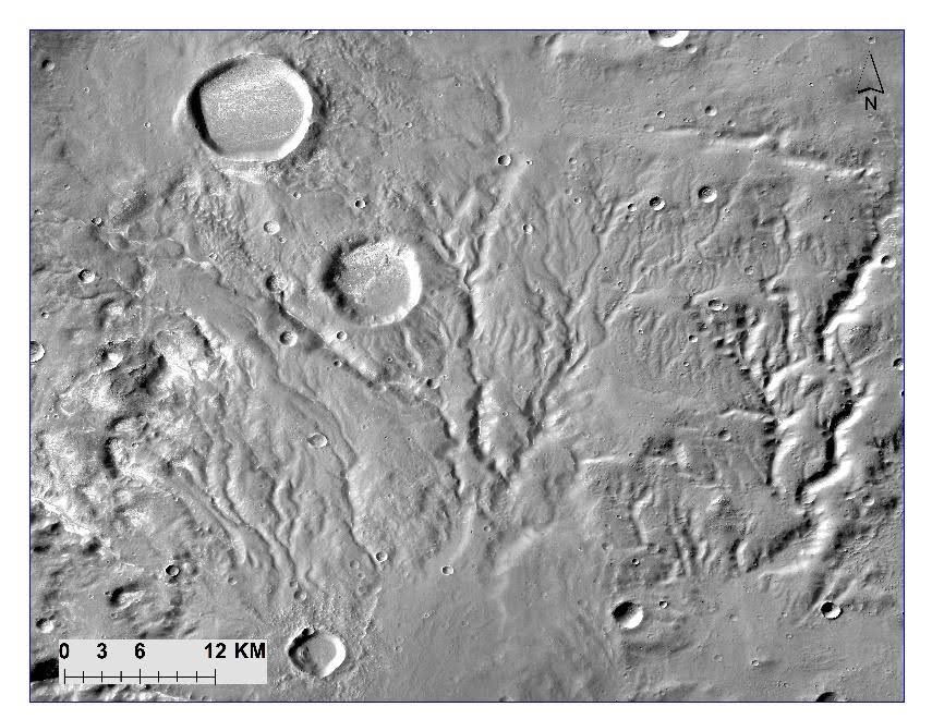
The researchers looked for qualitative features such as fan deposits (triangular or fan-shaped accumulations of sediment usually at the base of mountains) and branching and rejoining patterns, called anastomosing patterns, which are clear evidence of fluvial or water erosion. On the other hand, moraine-like features, which are landmasses formed by rock, soil, and other debris known as glacial till, viscous flow features and ribbed terrain, indicate glacial (ice) processes. Quantitatively, they used metrics such as the V-index, which distinguishes between V-shaped valley profiles, typically formed by water erosion, and U-shaped profiles, which are often associated with glacial or, occasionally, sapping processes.
“When water is flowing, it carries heavy materials at the bottom and cuts the ground vertically. So, the shape it carves is more of a V-shaped valley. Glaciers, which have a mix of ice and debris, are heavier. When they move, they slide over the surface and create a U-shaped valley,” explains Dibyendu Ghosh, the first author of the study.
Another key metric was the junction angle, the angle at which two valleys meet.
“When water is flowing, it follows the slope, so two valleys will flow parallel to each other and meet at an acute angle. Glaciers can move laterally, so the angles become more obtuse,” explains Dibyendu.
Thus, low junction angles (around 50 degrees) indicate flowing water, while higher angles indicate glacial flow.
The team found that the valleys closest to the equator, the low-latitude regions of Thaumasia, show evidence of a warm climate regime. The features here were primarily formed by fluvial processes, meaning they were carved by flowing water on the surface. However, as the team looked farther south toward higher latitudes, there was increasing evidence of fluvioglacial activity, where ice and glaciers form or modify valleys.
The study also confirms that the majority of the valley networks on Mars were carved predominantly by surface water during the planet's earliest major geological era, the Noachian period, around 4.1 to 3.7 billion years ago. As Mars transitioned into the Noachian-Hesperian period, valley formation began to decline, and the process shifted toward fluvioglacial activity, in which both water and glacial ice contributed to shaping the terrain.
By the Hesperian period, estimated to be around 3.7 to 3 billion years ago, valley formation was further reduced. The valleys showed increasing signs of modification by groundwater erosion and glacial processes, likely sourced from a subsurface cryosphere, or frozen ground. This sequence of evidence suggests a gradual climate change on Mars, starting warm and wet in the Noachian and becoming progressively colder and icier by the Hesperian and later.
“When you look at impact craters on Mars, if a meteorite hits a surface with layers of subsurface ice, it will generate a lot of slurry, which is thrown up and forms a distinctive debris pattern resembling a splash of mud or a viscous flow around the crater. If it were solid ground with no ice, there would be no slurry around the crater rim. We see both these types of craters on Mars. So, there must have been frozen water in the subsurface of parts of Mars, like Earth's permafrost. This gives us some idea where some of the water went,” explains Prof Porwal.
By systematically analysing the transition across different latitudes and geological ages, this study provides a more robust narrative of Mars’ climate shift. However, the researchers acknowledge that establishing a clear relationship between the valley networks, the underlying structural features, and the accurate geological ages of those events remains a big challenge.
Talking about his plans further to improve the understanding of the red planet’s history, Prof Porwal remarks, “If I had a chance to suggest (for a future Mars mission), I would recommend a lander to get more geophysical data. And an orbiter with high-resolution imaging and infrared imaging capabilities to thoroughly study its geological history.”


